 ROS Index

|
mujoco_3d_lidar package from mujoco_ros2_control repomujoco_3d_lidar mujoco_ros2_control mujoco_ros2_control_demos mujoco_ros2_control_msgs mujoco_ros2_control_plugins mujoco_ros2_control_tests |
ROS Distro
|
Package Summary
| Version | 0.1.3 |
| License | Apache-2.0 |
| Build type | AMENT_CMAKE |
| Use | RECOMMENDED |
Repository Summary
| Checkout URI | https://github.com/ros-controls/mujoco_ros2_control.git |
| VCS Type | git |
| VCS Version | main |
| Last Updated | 2026-10-16 |
| Dev Status | DEVELOPED |
| Released | RELEASED |
| Contributing |
Help Wanted (-)
Good First Issues (-) Pull Requests to Review (-) |
Package Description
Maintainers
- Jodi Graf
Authors
3-D Lidar Extension for Mujoco
Lidar
This sensor uses ray casting to simulate lidar.
A lidar sensor is associated with a site and finds the nearest collision points from the site along a set of vectors.
The vectors are determined by the size and field of view parameters.
The sensor is parametrizable with the following:
- Horizontal resolution (
size[0]). positive integer - Vertical resolution (
size[1]). positive integer - Horizontal field-of-view (
fov[0]). positive float in (0, 2 $\pi$.] radians - Vertical field-of-view(
fov[1]). positive float in (0, $\pi$] radians - Maximum Range. positive float greater than 0.0 (m)
- Minimum Range. positive float greater than 0.0 (m) (Optional, defaults to 0.0)
- Update Rate. positive float greater than 0.0 (Hz) (Optional, defaults to 0.0)
- Note. This may be removed in future versions after the interval attribute is available for sensors.
- Async. boolean int (0 for false, non-zero for true) (Optional, defaults to 0)
Field of view should always be in radians regardless of the compiler options.
The horizontal fov is divided by the horizontal resolution to compute the number of azimuth angles. The vertical fov is divided by the vertical resolution to compute the number of elevation angles. Each azimuth/elevation pair defines a vector. The distance result is the set of distances to collision from the site origin along that vector.
These parameters are passed as extension config attributes:
<mujoco>
  <extension>
    <plugin plugin="mujoco.sensor.lidar"/>
  </extension>
  ...
  <sensor>
    <plugin name="lidar" plugin="mujoco.plugin.lidar" objtype="site" objname="lidar_sensor">
      <config key="size" value="360 10"/>
      <config key="fov" value="6.2832 0.7854"/>
      <config key="max_range" value="13.0"/>
      <config key="min_range" value="1.0"/>
      <config key="update_rate" value="1.0"/>
      <config key="async" value="0"/>
    </plugin>
  </sensor>
</mujoco>
Note the following:
- The dimensionality of the sensor output is
size_x *size_y. -
objtype="site" objname="lidar"specify that the sensor is associated with a site, and the name of the specific site. - Field-of-view angles are always in radians.
- If async is specified, lidar computations are done in the background and data will be delayed.
Example model
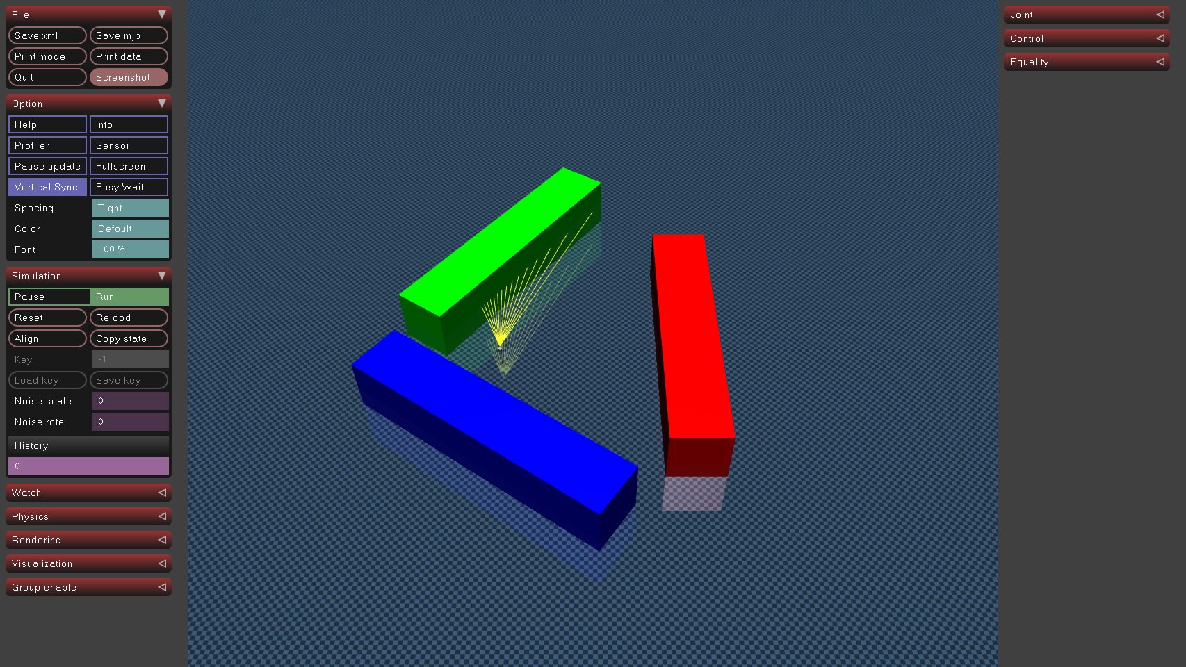 Lidar with:
horizontal fov = 45 deg,
vertical fov = 0,
horizontal size = 15,
vertical size = 1
Lidar with:
horizontal fov = 45 deg,
vertical fov = 0,
horizontal size = 15,
vertical size = 1
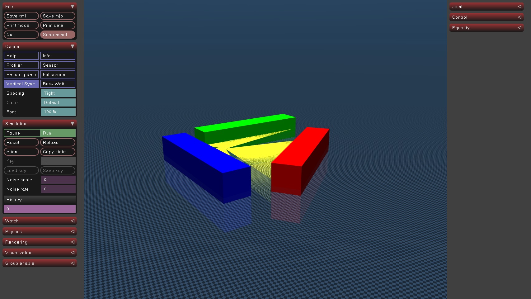 Lidar with:
horizontal fov = 360 deg,
vertical fov = 0,
horizontal size = 360,
vertical size = 1
Lidar with:
horizontal fov = 360 deg,
vertical fov = 0,
horizontal size = 360,
vertical size = 1
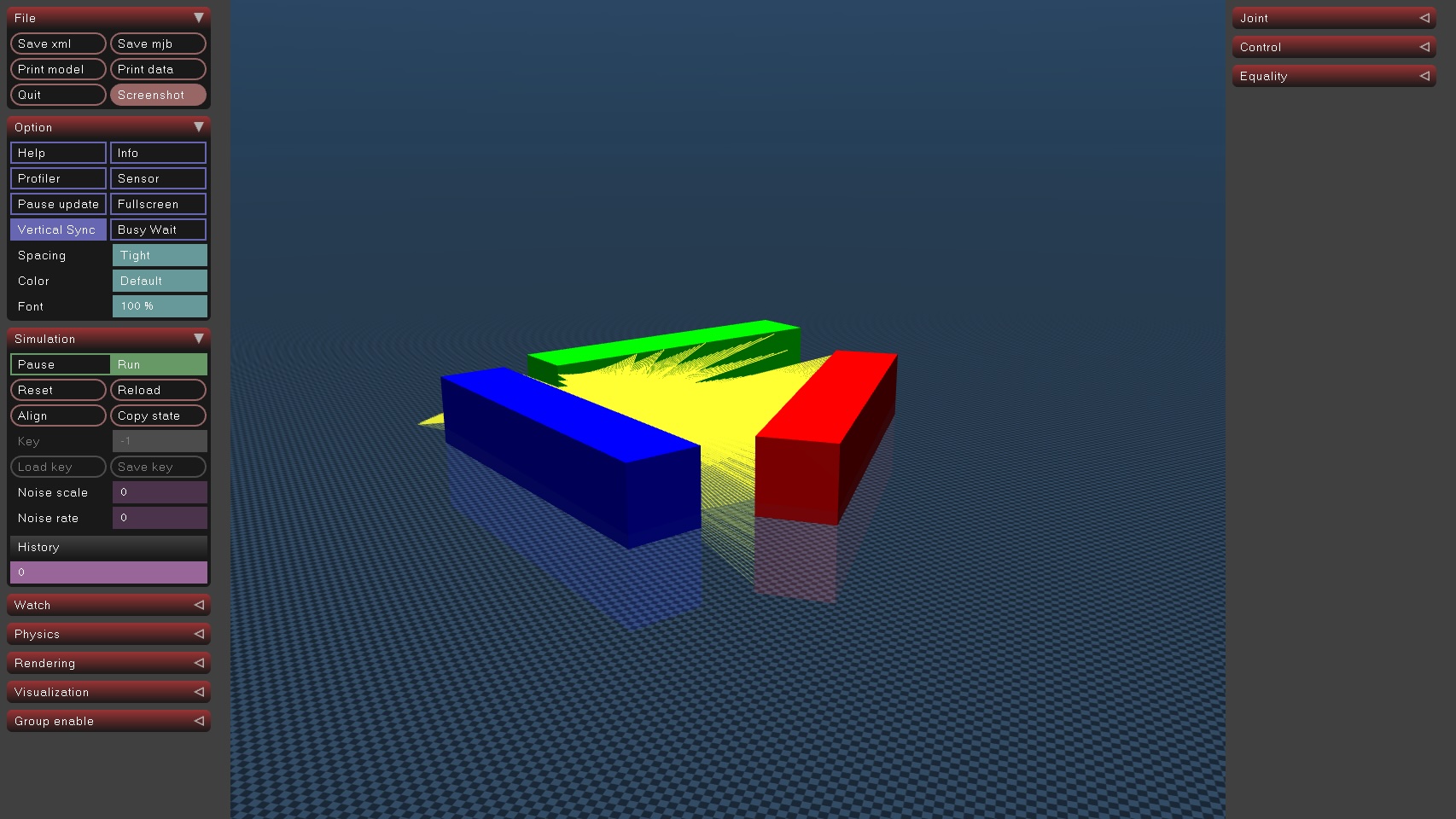 Lidar with:
horizontal fov = 360 deg,
vertical fov = 45,
horizontal size = 360,
vertical size = 4
Lidar with:
horizontal fov = 360 deg,
vertical fov = 45,
horizontal size = 360,
vertical size = 4
See lidar.xml to play with the model above.
Standalone Build
This package is intended to be build alongside the mujoco_ros2_control packages.
However, we maintain a standalone build in the event that users want to pull this out and use it separately.
To compile, ensure mujoco_vendor is installed and available.
From this package’s root:
mkdir build
cd build
cmake ..
make
This will create a mujoco_plugin directory alongside the mujoco binaries and install the lidar extension there. It can now be found.
File truncated at 100 lines see the full file
Changelog for package mujoco_3d_lidar
0.1.3 (2026-10-08)
0.1.2 (2026-09-07)
0.1.1 (2026-08-25)
- Fix compilation on MuJoCo 3.12.0 (#290)
- Fix the generate changelog of 0.1.0 (#288)
- Contributors: Sai Kishor Kothakota
0.1.0 (2026-08-18)
- Make CI tests more robust (#239)
- Add Plugin for the 3D Lidar Extension (#207)
- Update Pixi packages with pixi.lock (#223)
- Add a 3-D Lidar Extension (#205)
- Contributors: Erik Holum, Sai Kishor Kothakota
0.0.3 (2026-05-01)
0.0.2 (2026-03-17)
0.0.1 (2026-02-24)
Package Dependencies
| Deps | Name |
|---|---|
| ament_cmake | |
| mujoco_vendor |
System Dependencies
Dependant Packages
Launch files
Messages
Services
Plugins
Recent questions tagged mujoco_3d_lidar at Robotics Stack Exchange
|
|
mujoco_3d_lidar package from mujoco_ros2_control repomujoco_3d_lidar mujoco_ros2_control mujoco_ros2_control_demos mujoco_ros2_control_msgs mujoco_ros2_control_plugins mujoco_ros2_control_tests |
ROS Distro
|
Package Summary
| Version | 0.1.3 |
| License | Apache-2.0 |
| Build type | AMENT_CMAKE |
| Use | RECOMMENDED |
Repository Summary
| Checkout URI | https://github.com/ros-controls/mujoco_ros2_control.git |
| VCS Type | git |
| VCS Version | main |
| Last Updated | 2026-10-16 |
| Dev Status | DEVELOPED |
| Released | RELEASED |
| Contributing |
Help Wanted (-)
Good First Issues (-) Pull Requests to Review (-) |
Package Description
Maintainers
- Jodi Graf
Authors
3-D Lidar Extension for Mujoco
Lidar
This sensor uses ray casting to simulate lidar.
A lidar sensor is associated with a site and finds the nearest collision points from the site along a set of vectors.
The vectors are determined by the size and field of view parameters.
The sensor is parametrizable with the following:
- Horizontal resolution (
size[0]). positive integer - Vertical resolution (
size[1]). positive integer - Horizontal field-of-view (
fov[0]). positive float in (0, 2 $\pi$.] radians - Vertical field-of-view(
fov[1]). positive float in (0, $\pi$] radians - Maximum Range. positive float greater than 0.0 (m)
- Minimum Range. positive float greater than 0.0 (m) (Optional, defaults to 0.0)
- Update Rate. positive float greater than 0.0 (Hz) (Optional, defaults to 0.0)
- Note. This may be removed in future versions after the interval attribute is available for sensors.
- Async. boolean int (0 for false, non-zero for true) (Optional, defaults to 0)
Field of view should always be in radians regardless of the compiler options.
The horizontal fov is divided by the horizontal resolution to compute the number of azimuth angles. The vertical fov is divided by the vertical resolution to compute the number of elevation angles. Each azimuth/elevation pair defines a vector. The distance result is the set of distances to collision from the site origin along that vector.
These parameters are passed as extension config attributes:
<mujoco>
  <extension>
    <plugin plugin="mujoco.sensor.lidar"/>
  </extension>
  ...
  <sensor>
    <plugin name="lidar" plugin="mujoco.plugin.lidar" objtype="site" objname="lidar_sensor">
      <config key="size" value="360 10"/>
      <config key="fov" value="6.2832 0.7854"/>
      <config key="max_range" value="13.0"/>
      <config key="min_range" value="1.0"/>
      <config key="update_rate" value="1.0"/>
      <config key="async" value="0"/>
    </plugin>
  </sensor>
</mujoco>
Note the following:
- The dimensionality of the sensor output is
size_x *size_y. -
objtype="site" objname="lidar"specify that the sensor is associated with a site, and the name of the specific site. - Field-of-view angles are always in radians.
- If async is specified, lidar computations are done in the background and data will be delayed.
Example model
Lidar with:
horizontal fov = 45 deg,
vertical fov = 0,
horizontal size = 15,
vertical size = 1
Lidar with:
horizontal fov = 360 deg,
vertical fov = 0,
horizontal size = 360,
vertical size = 1
Lidar with:
horizontal fov = 360 deg,
vertical fov = 45,
horizontal size = 360,
vertical size = 4
See lidar.xml to play with the model above.
Standalone Build
This package is intended to be build alongside the mujoco_ros2_control packages.
However, we maintain a standalone build in the event that users want to pull this out and use it separately.
To compile, ensure mujoco_vendor is installed and available.
From this package’s root:
mkdir build
cd build
cmake ..
make
This will create a mujoco_plugin directory alongside the mujoco binaries and install the lidar extension there. It can now be found.
File truncated at 100 lines see the full file
Changelog for package mujoco_3d_lidar
0.1.3 (2026-10-08)
0.1.2 (2026-09-07)
0.1.1 (2026-08-25)
- Fix compilation on MuJoCo 3.12.0 (#290)
- Fix the generate changelog of 0.1.0 (#288)
- Contributors: Sai Kishor Kothakota
0.1.0 (2026-08-18)
- Make CI tests more robust (#239)
- Add Plugin for the 3D Lidar Extension (#207)
- Update Pixi packages with pixi.lock (#223)
- Add a 3-D Lidar Extension (#205)
- Contributors: Erik Holum, Sai Kishor Kothakota
0.0.3 (2026-05-01)
0.0.2 (2026-03-17)
0.0.1 (2026-02-24)
Package Dependencies
| Deps | Name |
|---|---|
| ament_cmake | |
| mujoco_vendor |
System Dependencies
Dependant Packages
Launch files
Messages
Services
Plugins
Recent questions tagged mujoco_3d_lidar at Robotics Stack Exchange
|
|
mujoco_3d_lidar package from mujoco_ros2_control repomujoco_3d_lidar mujoco_ros2_control mujoco_ros2_control_demos mujoco_ros2_control_msgs mujoco_ros2_control_plugins mujoco_ros2_control_tests |
ROS Distro
|
Package Summary
| Version | 0.1.3 |
| License | Apache-2.0 |
| Build type | AMENT_CMAKE |
| Use | RECOMMENDED |
Repository Summary
| Checkout URI | https://github.com/ros-controls/mujoco_ros2_control.git |
| VCS Type | git |
| VCS Version | main |
| Last Updated | 2026-10-16 |
| Dev Status | DEVELOPED |
| Released | RELEASED |
| Contributing |
Help Wanted (-)
Good First Issues (-) Pull Requests to Review (-) |
Package Description
Maintainers
- Jodi Graf
Authors
3-D Lidar Extension for Mujoco
Lidar
This sensor uses ray casting to simulate lidar.
A lidar sensor is associated with a site and finds the nearest collision points from the site along a set of vectors.
The vectors are determined by the size and field of view parameters.
The sensor is parametrizable with the following:
- Horizontal resolution (
size[0]). positive integer - Vertical resolution (
size[1]). positive integer - Horizontal field-of-view (
fov[0]). positive float in (0, 2 $\pi$.] radians - Vertical field-of-view(
fov[1]). positive float in (0, $\pi$] radians - Maximum Range. positive float greater than 0.0 (m)
- Minimum Range. positive float greater than 0.0 (m) (Optional, defaults to 0.0)
- Update Rate. positive float greater than 0.0 (Hz) (Optional, defaults to 0.0)
- Note. This may be removed in future versions after the interval attribute is available for sensors.
- Async. boolean int (0 for false, non-zero for true) (Optional, defaults to 0)
Field of view should always be in radians regardless of the compiler options.
The horizontal fov is divided by the horizontal resolution to compute the number of azimuth angles. The vertical fov is divided by the vertical resolution to compute the number of elevation angles. Each azimuth/elevation pair defines a vector. The distance result is the set of distances to collision from the site origin along that vector.
These parameters are passed as extension config attributes:
<mujoco>
  <extension>
    <plugin plugin="mujoco.sensor.lidar"/>
  </extension>
  ...
  <sensor>
    <plugin name="lidar" plugin="mujoco.plugin.lidar" objtype="site" objname="lidar_sensor">
      <config key="size" value="360 10"/>
      <config key="fov" value="6.2832 0.7854"/>
      <config key="max_range" value="13.0"/>
      <config key="min_range" value="1.0"/>
      <config key="update_rate" value="1.0"/>
      <config key="async" value="0"/>
    </plugin>
  </sensor>
</mujoco>
Note the following:
- The dimensionality of the sensor output is
size_x *size_y. -
objtype="site" objname="lidar"specify that the sensor is associated with a site, and the name of the specific site. - Field-of-view angles are always in radians.
- If async is specified, lidar computations are done in the background and data will be delayed.
Example model
Lidar with:
horizontal fov = 45 deg,
vertical fov = 0,
horizontal size = 15,
vertical size = 1
Lidar with:
horizontal fov = 360 deg,
vertical fov = 0,
horizontal size = 360,
vertical size = 1
Lidar with:
horizontal fov = 360 deg,
vertical fov = 45,
horizontal size = 360,
vertical size = 4
See lidar.xml to play with the model above.
Standalone Build
This package is intended to be build alongside the mujoco_ros2_control packages.
However, we maintain a standalone build in the event that users want to pull this out and use it separately.
To compile, ensure mujoco_vendor is installed and available.
From this package’s root:
mkdir build
cd build
cmake ..
make
This will create a mujoco_plugin directory alongside the mujoco binaries and install the lidar extension there. It can now be found.
File truncated at 100 lines see the full file
Changelog for package mujoco_3d_lidar
0.1.3 (2026-10-08)
0.1.2 (2026-09-07)
0.1.1 (2026-08-25)
- Fix compilation on MuJoCo 3.12.0 (#290)
- Fix the generate changelog of 0.1.0 (#288)
- Contributors: Sai Kishor Kothakota
0.1.0 (2026-08-18)
- Make CI tests more robust (#239)
- Add Plugin for the 3D Lidar Extension (#207)
- Update Pixi packages with pixi.lock (#223)
- Add a 3-D Lidar Extension (#205)
- Contributors: Erik Holum, Sai Kishor Kothakota
0.0.3 (2026-05-01)
0.0.2 (2026-03-17)
0.0.1 (2026-02-24)
Package Dependencies
| Deps | Name |
|---|---|
| ament_cmake | |
| mujoco_vendor |
System Dependencies
Dependant Packages
Launch files
Messages
Services
Plugins
Recent questions tagged mujoco_3d_lidar at Robotics Stack Exchange
|
|
mujoco_3d_lidar package from mujoco_ros2_control repomujoco_3d_lidar mujoco_ros2_control mujoco_ros2_control_demos mujoco_ros2_control_msgs mujoco_ros2_control_plugins mujoco_ros2_control_tests |
ROS Distro
|
Package Summary
| Version | 0.1.3 |
| License | Apache-2.0 |
| Build type | AMENT_CMAKE |
| Use | RECOMMENDED |
Repository Summary
| Checkout URI | https://github.com/ros-controls/mujoco_ros2_control.git |
| VCS Type | git |
| VCS Version | main |
| Last Updated | 2026-10-16 |
| Dev Status | DEVELOPED |
| Released | RELEASED |
| Contributing |
Help Wanted (-)
Good First Issues (-) Pull Requests to Review (-) |
Package Description
Maintainers
- Jodi Graf
Authors
3-D Lidar Extension for Mujoco
Lidar
This sensor uses ray casting to simulate lidar.
A lidar sensor is associated with a site and finds the nearest collision points from the site along a set of vectors.
The vectors are determined by the size and field of view parameters.
The sensor is parametrizable with the following:
- Horizontal resolution (
size[0]). positive integer - Vertical resolution (
size[1]). positive integer - Horizontal field-of-view (
fov[0]). positive float in (0, 2 $\pi$.] radians - Vertical field-of-view(
fov[1]). positive float in (0, $\pi$] radians - Maximum Range. positive float greater than 0.0 (m)
- Minimum Range. positive float greater than 0.0 (m) (Optional, defaults to 0.0)
- Update Rate. positive float greater than 0.0 (Hz) (Optional, defaults to 0.0)
- Note. This may be removed in future versions after the interval attribute is available for sensors.
- Async. boolean int (0 for false, non-zero for true) (Optional, defaults to 0)
Field of view should always be in radians regardless of the compiler options.
The horizontal fov is divided by the horizontal resolution to compute the number of azimuth angles. The vertical fov is divided by the vertical resolution to compute the number of elevation angles. Each azimuth/elevation pair defines a vector. The distance result is the set of distances to collision from the site origin along that vector.
These parameters are passed as extension config attributes:
<mujoco>
  <extension>
    <plugin plugin="mujoco.sensor.lidar"/>
  </extension>
  ...
  <sensor>
    <plugin name="lidar" plugin="mujoco.plugin.lidar" objtype="site" objname="lidar_sensor">
      <config key="size" value="360 10"/>
      <config key="fov" value="6.2832 0.7854"/>
      <config key="max_range" value="13.0"/>
      <config key="min_range" value="1.0"/>
      <config key="update_rate" value="1.0"/>
      <config key="async" value="0"/>
    </plugin>
  </sensor>
</mujoco>
Note the following:
- The dimensionality of the sensor output is
size_x *size_y. -
objtype="site" objname="lidar"specify that the sensor is associated with a site, and the name of the specific site. - Field-of-view angles are always in radians.
- If async is specified, lidar computations are done in the background and data will be delayed.
Example model
Lidar with:
horizontal fov = 45 deg,
vertical fov = 0,
horizontal size = 15,
vertical size = 1
Lidar with:
horizontal fov = 360 deg,
vertical fov = 0,
horizontal size = 360,
vertical size = 1
Lidar with:
horizontal fov = 360 deg,
vertical fov = 45,
horizontal size = 360,
vertical size = 4
See lidar.xml to play with the model above.
Standalone Build
This package is intended to be build alongside the mujoco_ros2_control packages.
However, we maintain a standalone build in the event that users want to pull this out and use it separately.
To compile, ensure mujoco_vendor is installed and available.
From this package’s root:
mkdir build
cd build
cmake ..
make
This will create a mujoco_plugin directory alongside the mujoco binaries and install the lidar extension there. It can now be found.
File truncated at 100 lines see the full file
Changelog for package mujoco_3d_lidar
0.1.3 (2026-10-08)
0.1.2 (2026-09-07)
0.1.1 (2026-08-25)
- Fix compilation on MuJoCo 3.12.0 (#290)
- Fix the generate changelog of 0.1.0 (#288)
- Contributors: Sai Kishor Kothakota
0.1.0 (2026-08-18)
- Make CI tests more robust (#239)
- Add Plugin for the 3D Lidar Extension (#207)
- Update Pixi packages with pixi.lock (#223)
- Add a 3-D Lidar Extension (#205)
- Contributors: Erik Holum, Sai Kishor Kothakota
0.0.3 (2026-05-01)
0.0.2 (2026-03-17)
0.0.1 (2026-02-24)
Package Dependencies
| Deps | Name |
|---|---|
| ament_cmake | |
| mujoco_vendor |
System Dependencies
Dependant Packages
Launch files
Messages
Services
Plugins
Recent questions tagged mujoco_3d_lidar at Robotics Stack Exchange
|
|
mujoco_3d_lidar package from mujoco_ros2_control repomujoco_3d_lidar mujoco_ros2_control mujoco_ros2_control_demos mujoco_ros2_control_msgs mujoco_ros2_control_plugins mujoco_ros2_control_tests |
ROS Distro
|
Package Summary
| Version | 0.1.3 |
| License | Apache-2.0 |
| Build type | AMENT_CMAKE |
| Use | RECOMMENDED |
Repository Summary
| Checkout URI | https://github.com/ros-controls/mujoco_ros2_control.git |
| VCS Type | git |
| VCS Version | main |
| Last Updated | 2026-10-16 |
| Dev Status | DEVELOPED |
| Released | RELEASED |
| Contributing |
Help Wanted (-)
Good First Issues (-) Pull Requests to Review (-) |
Package Description
Maintainers
- Jodi Graf
Authors
3-D Lidar Extension for Mujoco
Lidar
This sensor uses ray casting to simulate lidar.
A lidar sensor is associated with a site and finds the nearest collision points from the site along a set of vectors.
The vectors are determined by the size and field of view parameters.
The sensor is parametrizable with the following:
- Horizontal resolution (
size[0]). positive integer - Vertical resolution (
size[1]). positive integer - Horizontal field-of-view (
fov[0]). positive float in (0, 2 $\pi$.] radians - Vertical field-of-view(
fov[1]). positive float in (0, $\pi$] radians - Maximum Range. positive float greater than 0.0 (m)
- Minimum Range. positive float greater than 0.0 (m) (Optional, defaults to 0.0)
- Update Rate. positive float greater than 0.0 (Hz) (Optional, defaults to 0.0)
- Note. This may be removed in future versions after the interval attribute is available for sensors.
- Async. boolean int (0 for false, non-zero for true) (Optional, defaults to 0)
Field of view should always be in radians regardless of the compiler options.
The horizontal fov is divided by the horizontal resolution to compute the number of azimuth angles. The vertical fov is divided by the vertical resolution to compute the number of elevation angles. Each azimuth/elevation pair defines a vector. The distance result is the set of distances to collision from the site origin along that vector.
These parameters are passed as extension config attributes:
<mujoco>
  <extension>
    <plugin plugin="mujoco.sensor.lidar"/>
  </extension>
  ...
  <sensor>
    <plugin name="lidar" plugin="mujoco.plugin.lidar" objtype="site" objname="lidar_sensor">
      <config key="size" value="360 10"/>
      <config key="fov" value="6.2832 0.7854"/>
      <config key="max_range" value="13.0"/>
      <config key="min_range" value="1.0"/>
      <config key="update_rate" value="1.0"/>
      <config key="async" value="0"/>
    </plugin>
  </sensor>
</mujoco>
Note the following:
- The dimensionality of the sensor output is
size_x *size_y. -
objtype="site" objname="lidar"specify that the sensor is associated with a site, and the name of the specific site. - Field-of-view angles are always in radians.
- If async is specified, lidar computations are done in the background and data will be delayed.
Example model
Lidar with:
horizontal fov = 45 deg,
vertical fov = 0,
horizontal size = 15,
vertical size = 1
Lidar with:
horizontal fov = 360 deg,
vertical fov = 0,
horizontal size = 360,
vertical size = 1
Lidar with:
horizontal fov = 360 deg,
vertical fov = 45,
horizontal size = 360,
vertical size = 4
See lidar.xml to play with the model above.
Standalone Build
This package is intended to be build alongside the mujoco_ros2_control packages.
However, we maintain a standalone build in the event that users want to pull this out and use it separately.
To compile, ensure mujoco_vendor is installed and available.
From this package’s root:
mkdir build
cd build
cmake ..
make
This will create a mujoco_plugin directory alongside the mujoco binaries and install the lidar extension there. It can now be found.
File truncated at 100 lines see the full file
Changelog for package mujoco_3d_lidar
0.1.3 (2026-10-08)
0.1.2 (2026-09-07)
0.1.1 (2026-08-25)
- Fix compilation on MuJoCo 3.12.0 (#290)
- Fix the generate changelog of 0.1.0 (#288)
- Contributors: Sai Kishor Kothakota
0.1.0 (2026-08-18)
- Make CI tests more robust (#239)
- Add Plugin for the 3D Lidar Extension (#207)
- Update Pixi packages with pixi.lock (#223)
- Add a 3-D Lidar Extension (#205)
- Contributors: Erik Holum, Sai Kishor Kothakota
0.0.3 (2026-05-01)
0.0.2 (2026-03-17)
0.0.1 (2026-02-24)
Package Dependencies
| Deps | Name |
|---|---|
| ament_cmake | |
| mujoco_vendor |
System Dependencies
Dependant Packages
Launch files
Messages
Services
Plugins
Recent questions tagged mujoco_3d_lidar at Robotics Stack Exchange
|
|
mujoco_3d_lidar package from mujoco_ros2_control repomujoco_3d_lidar mujoco_ros2_control mujoco_ros2_control_demos mujoco_ros2_control_msgs mujoco_ros2_control_plugins mujoco_ros2_control_tests |
ROS Distro
|
Package Summary
| Version | 0.1.3 |
| License | Apache-2.0 |
| Build type | AMENT_CMAKE |
| Use | RECOMMENDED |
Repository Summary
| Checkout URI | https://github.com/ros-controls/mujoco_ros2_control.git |
| VCS Type | git |
| VCS Version | main |
| Last Updated | 2026-10-16 |
| Dev Status | DEVELOPED |
| Released | RELEASED |
| Contributing |
Help Wanted (-)
Good First Issues (-) Pull Requests to Review (-) |
Package Description
Maintainers
- Jodi Graf
Authors
3-D Lidar Extension for Mujoco
Lidar
This sensor uses ray casting to simulate lidar.
A lidar sensor is associated with a site and finds the nearest collision points from the site along a set of vectors.
The vectors are determined by the size and field of view parameters.
The sensor is parametrizable with the following:
- Horizontal resolution (
size[0]). positive integer - Vertical resolution (
size[1]). positive integer - Horizontal field-of-view (
fov[0]). positive float in (0, 2 $\pi$.] radians - Vertical field-of-view(
fov[1]). positive float in (0, $\pi$] radians - Maximum Range. positive float greater than 0.0 (m)
- Minimum Range. positive float greater than 0.0 (m) (Optional, defaults to 0.0)
- Update Rate. positive float greater than 0.0 (Hz) (Optional, defaults to 0.0)
- Note. This may be removed in future versions after the interval attribute is available for sensors.
- Async. boolean int (0 for false, non-zero for true) (Optional, defaults to 0)
Field of view should always be in radians regardless of the compiler options.
The horizontal fov is divided by the horizontal resolution to compute the number of azimuth angles. The vertical fov is divided by the vertical resolution to compute the number of elevation angles. Each azimuth/elevation pair defines a vector. The distance result is the set of distances to collision from the site origin along that vector.
These parameters are passed as extension config attributes:
<mujoco>
  <extension>
    <plugin plugin="mujoco.sensor.lidar"/>
  </extension>
  ...
  <sensor>
    <plugin name="lidar" plugin="mujoco.plugin.lidar" objtype="site" objname="lidar_sensor">
      <config key="size" value="360 10"/>
      <config key="fov" value="6.2832 0.7854"/>
      <config key="max_range" value="13.0"/>
      <config key="min_range" value="1.0"/>
      <config key="update_rate" value="1.0"/>
      <config key="async" value="0"/>
    </plugin>
  </sensor>
</mujoco>
Note the following:
- The dimensionality of the sensor output is
size_x *size_y. -
objtype="site" objname="lidar"specify that the sensor is associated with a site, and the name of the specific site. - Field-of-view angles are always in radians.
- If async is specified, lidar computations are done in the background and data will be delayed.
Example model
Lidar with:
horizontal fov = 45 deg,
vertical fov = 0,
horizontal size = 15,
vertical size = 1
Lidar with:
horizontal fov = 360 deg,
vertical fov = 0,
horizontal size = 360,
vertical size = 1
Lidar with:
horizontal fov = 360 deg,
vertical fov = 45,
horizontal size = 360,
vertical size = 4
See lidar.xml to play with the model above.
Standalone Build
This package is intended to be build alongside the mujoco_ros2_control packages.
However, we maintain a standalone build in the event that users want to pull this out and use it separately.
To compile, ensure mujoco_vendor is installed and available.
From this package’s root:
mkdir build
cd build
cmake ..
make
This will create a mujoco_plugin directory alongside the mujoco binaries and install the lidar extension there. It can now be found.
File truncated at 100 lines see the full file
Changelog for package mujoco_3d_lidar
0.1.3 (2026-10-08)
0.1.2 (2026-09-07)
0.1.1 (2026-08-25)
- Fix compilation on MuJoCo 3.12.0 (#290)
- Fix the generate changelog of 0.1.0 (#288)
- Contributors: Sai Kishor Kothakota
0.1.0 (2026-08-18)
- Make CI tests more robust (#239)
- Add Plugin for the 3D Lidar Extension (#207)
- Update Pixi packages with pixi.lock (#223)
- Add a 3-D Lidar Extension (#205)
- Contributors: Erik Holum, Sai Kishor Kothakota
0.0.3 (2026-05-01)
0.0.2 (2026-03-17)
0.0.1 (2026-02-24)
Package Dependencies
| Deps | Name |
|---|---|
| ament_cmake | |
| mujoco_vendor |
System Dependencies
Dependant Packages
Launch files
Messages
Services
Plugins
Recent questions tagged mujoco_3d_lidar at Robotics Stack Exchange
|
|
mujoco_3d_lidar package from mujoco_ros2_control repomujoco_3d_lidar mujoco_ros2_control mujoco_ros2_control_demos mujoco_ros2_control_msgs mujoco_ros2_control_plugins mujoco_ros2_control_tests |
ROS Distro
|
Package Summary
| Version | 0.1.3 |
| License | Apache-2.0 |
| Build type | AMENT_CMAKE |
| Use | RECOMMENDED |
Repository Summary
| Checkout URI | https://github.com/ros-controls/mujoco_ros2_control.git |
| VCS Type | git |
| VCS Version | main |
| Last Updated | 2026-10-16 |
| Dev Status | DEVELOPED |
| Released | RELEASED |
| Contributing |
Help Wanted (-)
Good First Issues (-) Pull Requests to Review (-) |
Package Description
Maintainers
- Jodi Graf
Authors
3-D Lidar Extension for Mujoco
Lidar
This sensor uses ray casting to simulate lidar.
A lidar sensor is associated with a site and finds the nearest collision points from the site along a set of vectors.
The vectors are determined by the size and field of view parameters.
The sensor is parametrizable with the following:
- Horizontal resolution (
size[0]). positive integer - Vertical resolution (
size[1]). positive integer - Horizontal field-of-view (
fov[0]). positive float in (0, 2 $\pi$.] radians - Vertical field-of-view(
fov[1]). positive float in (0, $\pi$] radians - Maximum Range. positive float greater than 0.0 (m)
- Minimum Range. positive float greater than 0.0 (m) (Optional, defaults to 0.0)
- Update Rate. positive float greater than 0.0 (Hz) (Optional, defaults to 0.0)
- Note. This may be removed in future versions after the interval attribute is available for sensors.
- Async. boolean int (0 for false, non-zero for true) (Optional, defaults to 0)
Field of view should always be in radians regardless of the compiler options.
The horizontal fov is divided by the horizontal resolution to compute the number of azimuth angles. The vertical fov is divided by the vertical resolution to compute the number of elevation angles. Each azimuth/elevation pair defines a vector. The distance result is the set of distances to collision from the site origin along that vector.
These parameters are passed as extension config attributes:
<mujoco>
  <extension>
    <plugin plugin="mujoco.sensor.lidar"/>
  </extension>
  ...
  <sensor>
    <plugin name="lidar" plugin="mujoco.plugin.lidar" objtype="site" objname="lidar_sensor">
      <config key="size" value="360 10"/>
      <config key="fov" value="6.2832 0.7854"/>
      <config key="max_range" value="13.0"/>
      <config key="min_range" value="1.0"/>
      <config key="update_rate" value="1.0"/>
      <config key="async" value="0"/>
    </plugin>
  </sensor>
</mujoco>
Note the following:
- The dimensionality of the sensor output is
size_x *size_y. -
objtype="site" objname="lidar"specify that the sensor is associated with a site, and the name of the specific site. - Field-of-view angles are always in radians.
- If async is specified, lidar computations are done in the background and data will be delayed.
Example model
Lidar with:
horizontal fov = 45 deg,
vertical fov = 0,
horizontal size = 15,
vertical size = 1
Lidar with:
horizontal fov = 360 deg,
vertical fov = 0,
horizontal size = 360,
vertical size = 1
Lidar with:
horizontal fov = 360 deg,
vertical fov = 45,
horizontal size = 360,
vertical size = 4
See lidar.xml to play with the model above.
Standalone Build
This package is intended to be build alongside the mujoco_ros2_control packages.
However, we maintain a standalone build in the event that users want to pull this out and use it separately.
To compile, ensure mujoco_vendor is installed and available.
From this package’s root:
mkdir build
cd build
cmake ..
make
This will create a mujoco_plugin directory alongside the mujoco binaries and install the lidar extension there. It can now be found.
File truncated at 100 lines see the full file
Changelog for package mujoco_3d_lidar
0.1.3 (2026-10-08)
0.1.2 (2026-09-07)
0.1.1 (2026-08-25)
- Fix compilation on MuJoCo 3.12.0 (#290)
- Fix the generate changelog of 0.1.0 (#288)
- Contributors: Sai Kishor Kothakota
0.1.0 (2026-08-18)
- Make CI tests more robust (#239)
- Add Plugin for the 3D Lidar Extension (#207)
- Update Pixi packages with pixi.lock (#223)
- Add a 3-D Lidar Extension (#205)
- Contributors: Erik Holum, Sai Kishor Kothakota
0.0.3 (2026-05-01)
0.0.2 (2026-03-17)
0.0.1 (2026-02-24)
Package Dependencies
| Deps | Name |
|---|---|
| ament_cmake | |
| mujoco_vendor |
System Dependencies
Dependant Packages
Launch files
Messages
Services
Plugins
Recent questions tagged mujoco_3d_lidar at Robotics Stack Exchange
|
|
mujoco_3d_lidar package from mujoco_ros2_control repomujoco_3d_lidar mujoco_ros2_control mujoco_ros2_control_demos mujoco_ros2_control_msgs mujoco_ros2_control_plugins mujoco_ros2_control_tests |
ROS Distro
|
Package Summary
| Version | 0.1.3 |
| License | Apache-2.0 |
| Build type | AMENT_CMAKE |
| Use | RECOMMENDED |
Repository Summary
| Checkout URI | https://github.com/ros-controls/mujoco_ros2_control.git |
| VCS Type | git |
| VCS Version | main |
| Last Updated | 2026-10-16 |
| Dev Status | DEVELOPED |
| Released | RELEASED |
| Contributing |
Help Wanted (-)
Good First Issues (-) Pull Requests to Review (-) |
Package Description
Maintainers
- Jodi Graf
Authors
3-D Lidar Extension for Mujoco
Lidar
This sensor uses ray casting to simulate lidar.
A lidar sensor is associated with a site and finds the nearest collision points from the site along a set of vectors.
The vectors are determined by the size and field of view parameters.
The sensor is parametrizable with the following:
- Horizontal resolution (
size[0]). positive integer - Vertical resolution (
size[1]). positive integer - Horizontal field-of-view (
fov[0]). positive float in (0, 2 $\pi$.] radians - Vertical field-of-view(
fov[1]). positive float in (0, $\pi$] radians - Maximum Range. positive float greater than 0.0 (m)
- Minimum Range. positive float greater than 0.0 (m) (Optional, defaults to 0.0)
- Update Rate. positive float greater than 0.0 (Hz) (Optional, defaults to 0.0)
- Note. This may be removed in future versions after the interval attribute is available for sensors.
- Async. boolean int (0 for false, non-zero for true) (Optional, defaults to 0)
Field of view should always be in radians regardless of the compiler options.
The horizontal fov is divided by the horizontal resolution to compute the number of azimuth angles. The vertical fov is divided by the vertical resolution to compute the number of elevation angles. Each azimuth/elevation pair defines a vector. The distance result is the set of distances to collision from the site origin along that vector.
These parameters are passed as extension config attributes:
<mujoco>
  <extension>
    <plugin plugin="mujoco.sensor.lidar"/>
  </extension>
  ...
  <sensor>
    <plugin name="lidar" plugin="mujoco.plugin.lidar" objtype="site" objname="lidar_sensor">
      <config key="size" value="360 10"/>
      <config key="fov" value="6.2832 0.7854"/>
      <config key="max_range" value="13.0"/>
      <config key="min_range" value="1.0"/>
      <config key="update_rate" value="1.0"/>
      <config key="async" value="0"/>
    </plugin>
  </sensor>
</mujoco>
Note the following:
- The dimensionality of the sensor output is
size_x *size_y. -
objtype="site" objname="lidar"specify that the sensor is associated with a site, and the name of the specific site. - Field-of-view angles are always in radians.
- If async is specified, lidar computations are done in the background and data will be delayed.
Example model
Lidar with:
horizontal fov = 45 deg,
vertical fov = 0,
horizontal size = 15,
vertical size = 1
Lidar with:
horizontal fov = 360 deg,
vertical fov = 0,
horizontal size = 360,
vertical size = 1
Lidar with:
horizontal fov = 360 deg,
vertical fov = 45,
horizontal size = 360,
vertical size = 4
See lidar.xml to play with the model above.
Standalone Build
This package is intended to be build alongside the mujoco_ros2_control packages.
However, we maintain a standalone build in the event that users want to pull this out and use it separately.
To compile, ensure mujoco_vendor is installed and available.
From this package’s root:
mkdir build
cd build
cmake ..
make
This will create a mujoco_plugin directory alongside the mujoco binaries and install the lidar extension there. It can now be found.
File truncated at 100 lines see the full file
Changelog for package mujoco_3d_lidar
0.1.3 (2026-10-08)
0.1.2 (2026-09-07)
0.1.1 (2026-08-25)
- Fix compilation on MuJoCo 3.12.0 (#290)
- Fix the generate changelog of 0.1.0 (#288)
- Contributors: Sai Kishor Kothakota
0.1.0 (2026-08-18)
- Make CI tests more robust (#239)
- Add Plugin for the 3D Lidar Extension (#207)
- Update Pixi packages with pixi.lock (#223)
- Add a 3-D Lidar Extension (#205)
- Contributors: Erik Holum, Sai Kishor Kothakota
0.0.3 (2026-05-01)
0.0.2 (2026-03-17)
0.0.1 (2026-02-24)
Package Dependencies
| Deps | Name |
|---|---|
| ament_cmake | |
| mujoco_vendor |
System Dependencies
Dependant Packages
Launch files
Messages
Services
Plugins
Recent questions tagged mujoco_3d_lidar at Robotics Stack Exchange
|
|
mujoco_3d_lidar package from mujoco_ros2_control repomujoco_3d_lidar mujoco_ros2_control mujoco_ros2_control_demos mujoco_ros2_control_msgs mujoco_ros2_control_plugins mujoco_ros2_control_tests |
ROS Distro
|
Package Summary
| Version | 0.1.3 |
| License | Apache-2.0 |
| Build type | AMENT_CMAKE |
| Use | RECOMMENDED |
Repository Summary
| Checkout URI | https://github.com/ros-controls/mujoco_ros2_control.git |
| VCS Type | git |
| VCS Version | main |
| Last Updated | 2026-10-16 |
| Dev Status | DEVELOPED |
| Released | RELEASED |
| Contributing |
Help Wanted (-)
Good First Issues (-) Pull Requests to Review (-) |
Package Description
Maintainers
- Jodi Graf
Authors
3-D Lidar Extension for Mujoco
Lidar
This sensor uses ray casting to simulate lidar.
A lidar sensor is associated with a site and finds the nearest collision points from the site along a set of vectors.
The vectors are determined by the size and field of view parameters.
The sensor is parametrizable with the following:
- Horizontal resolution (
size[0]). positive integer - Vertical resolution (
size[1]). positive integer - Horizontal field-of-view (
fov[0]). positive float in (0, 2 $\pi$.] radians - Vertical field-of-view(
fov[1]). positive float in (0, $\pi$] radians - Maximum Range. positive float greater than 0.0 (m)
- Minimum Range. positive float greater than 0.0 (m) (Optional, defaults to 0.0)
- Update Rate. positive float greater than 0.0 (Hz) (Optional, defaults to 0.0)
- Note. This may be removed in future versions after the interval attribute is available for sensors.
- Async. boolean int (0 for false, non-zero for true) (Optional, defaults to 0)
Field of view should always be in radians regardless of the compiler options.
The horizontal fov is divided by the horizontal resolution to compute the number of azimuth angles. The vertical fov is divided by the vertical resolution to compute the number of elevation angles. Each azimuth/elevation pair defines a vector. The distance result is the set of distances to collision from the site origin along that vector.
These parameters are passed as extension config attributes:
<mujoco>
  <extension>
    <plugin plugin="mujoco.sensor.lidar"/>
  </extension>
  ...
  <sensor>
    <plugin name="lidar" plugin="mujoco.plugin.lidar" objtype="site" objname="lidar_sensor">
      <config key="size" value="360 10"/>
      <config key="fov" value="6.2832 0.7854"/>
      <config key="max_range" value="13.0"/>
      <config key="min_range" value="1.0"/>
      <config key="update_rate" value="1.0"/>
      <config key="async" value="0"/>
    </plugin>
  </sensor>
</mujoco>
Note the following:
- The dimensionality of the sensor output is
size_x *size_y. -
objtype="site" objname="lidar"specify that the sensor is associated with a site, and the name of the specific site. - Field-of-view angles are always in radians.
- If async is specified, lidar computations are done in the background and data will be delayed.
Example model
Lidar with:
horizontal fov = 45 deg,
vertical fov = 0,
horizontal size = 15,
vertical size = 1
Lidar with:
horizontal fov = 360 deg,
vertical fov = 0,
horizontal size = 360,
vertical size = 1
Lidar with:
horizontal fov = 360 deg,
vertical fov = 45,
horizontal size = 360,
vertical size = 4
See lidar.xml to play with the model above.
Standalone Build
This package is intended to be build alongside the mujoco_ros2_control packages.
However, we maintain a standalone build in the event that users want to pull this out and use it separately.
To compile, ensure mujoco_vendor is installed and available.
From this package’s root:
mkdir build
cd build
cmake ..
make
This will create a mujoco_plugin directory alongside the mujoco binaries and install the lidar extension there. It can now be found.
File truncated at 100 lines see the full file
Changelog for package mujoco_3d_lidar
0.1.3 (2026-10-08)
0.1.2 (2026-09-07)
0.1.1 (2026-08-25)
- Fix compilation on MuJoCo 3.12.0 (#290)
- Fix the generate changelog of 0.1.0 (#288)
- Contributors: Sai Kishor Kothakota
0.1.0 (2026-08-18)
- Make CI tests more robust (#239)
- Add Plugin for the 3D Lidar Extension (#207)
- Update Pixi packages with pixi.lock (#223)
- Add a 3-D Lidar Extension (#205)
- Contributors: Erik Holum, Sai Kishor Kothakota
0.0.3 (2026-05-01)
0.0.2 (2026-03-17)
0.0.1 (2026-02-24)
Package Dependencies
| Deps | Name |
|---|---|
| ament_cmake | |
| mujoco_vendor |
System Dependencies
Dependant Packages
Launch files
Messages
Services
Plugins
Recent questions tagged mujoco_3d_lidar at Robotics Stack Exchange
|
|
mujoco_3d_lidar package from mujoco_ros2_control repomujoco_3d_lidar mujoco_ros2_control mujoco_ros2_control_demos mujoco_ros2_control_msgs mujoco_ros2_control_plugins mujoco_ros2_control_tests |
ROS Distro
|
Package Summary
| Version | 0.1.3 |
| License | Apache-2.0 |
| Build type | AMENT_CMAKE |
| Use | RECOMMENDED |
Repository Summary
| Checkout URI | https://github.com/ros-controls/mujoco_ros2_control.git |
| VCS Type | git |
| VCS Version | main |
| Last Updated | 2026-10-16 |
| Dev Status | DEVELOPED |
| Released | RELEASED |
| Contributing |
Help Wanted (-)
Good First Issues (-) Pull Requests to Review (-) |
Package Description
Maintainers
- Jodi Graf
Authors
3-D Lidar Extension for Mujoco
Lidar
This sensor uses ray casting to simulate lidar.
A lidar sensor is associated with a site and finds the nearest collision points from the site along a set of vectors.
The vectors are determined by the size and field of view parameters.
The sensor is parametrizable with the following:
- Horizontal resolution (
size[0]). positive integer - Vertical resolution (
size[1]). positive integer - Horizontal field-of-view (
fov[0]). positive float in (0, 2 $\pi$.] radians - Vertical field-of-view(
fov[1]). positive float in (0, $\pi$] radians - Maximum Range. positive float greater than 0.0 (m)
- Minimum Range. positive float greater than 0.0 (m) (Optional, defaults to 0.0)
- Update Rate. positive float greater than 0.0 (Hz) (Optional, defaults to 0.0)
- Note. This may be removed in future versions after the interval attribute is available for sensors.
- Async. boolean int (0 for false, non-zero for true) (Optional, defaults to 0)
Field of view should always be in radians regardless of the compiler options.
The horizontal fov is divided by the horizontal resolution to compute the number of azimuth angles. The vertical fov is divided by the vertical resolution to compute the number of elevation angles. Each azimuth/elevation pair defines a vector. The distance result is the set of distances to collision from the site origin along that vector.
These parameters are passed as extension config attributes:
<mujoco>
  <extension>
    <plugin plugin="mujoco.sensor.lidar"/>
  </extension>
  ...
  <sensor>
    <plugin name="lidar" plugin="mujoco.plugin.lidar" objtype="site" objname="lidar_sensor">
      <config key="size" value="360 10"/>
      <config key="fov" value="6.2832 0.7854"/>
      <config key="max_range" value="13.0"/>
      <config key="min_range" value="1.0"/>
      <config key="update_rate" value="1.0"/>
      <config key="async" value="0"/>
    </plugin>
  </sensor>
</mujoco>
Note the following:
- The dimensionality of the sensor output is
size_x *size_y. -
objtype="site" objname="lidar"specify that the sensor is associated with a site, and the name of the specific site. - Field-of-view angles are always in radians.
- If async is specified, lidar computations are done in the background and data will be delayed.
Example model
Lidar with:
horizontal fov = 45 deg,
vertical fov = 0,
horizontal size = 15,
vertical size = 1
Lidar with:
horizontal fov = 360 deg,
vertical fov = 0,
horizontal size = 360,
vertical size = 1
Lidar with:
horizontal fov = 360 deg,
vertical fov = 45,
horizontal size = 360,
vertical size = 4
See lidar.xml to play with the model above.
Standalone Build
This package is intended to be build alongside the mujoco_ros2_control packages.
However, we maintain a standalone build in the event that users want to pull this out and use it separately.
To compile, ensure mujoco_vendor is installed and available.
From this package’s root:
mkdir build
cd build
cmake ..
make
This will create a mujoco_plugin directory alongside the mujoco binaries and install the lidar extension there. It can now be found.
File truncated at 100 lines see the full file
Changelog for package mujoco_3d_lidar
0.1.3 (2026-10-08)
0.1.2 (2026-09-07)
0.1.1 (2026-08-25)
- Fix compilation on MuJoCo 3.12.0 (#290)
- Fix the generate changelog of 0.1.0 (#288)
- Contributors: Sai Kishor Kothakota
0.1.0 (2026-08-18)
- Make CI tests more robust (#239)
- Add Plugin for the 3D Lidar Extension (#207)
- Update Pixi packages with pixi.lock (#223)
- Add a 3-D Lidar Extension (#205)
- Contributors: Erik Holum, Sai Kishor Kothakota
0.0.3 (2026-05-01)
0.0.2 (2026-03-17)
0.0.1 (2026-02-24)
Package Dependencies
| Deps | Name |
|---|---|
| ament_cmake | |
| mujoco_vendor |
System Dependencies
Dependant Packages
Launch files
Messages
Services
Plugins
Recent questions tagged mujoco_3d_lidar at Robotics Stack Exchange
|
|
mujoco_3d_lidar package from mujoco_ros2_control repomujoco_3d_lidar mujoco_ros2_control mujoco_ros2_control_demos mujoco_ros2_control_msgs mujoco_ros2_control_plugins mujoco_ros2_control_tests |
ROS Distro
|
Package Summary
| Version | 0.1.3 |
| License | Apache-2.0 |
| Build type | AMENT_CMAKE |
| Use | RECOMMENDED |
Repository Summary
| Checkout URI | https://github.com/ros-controls/mujoco_ros2_control.git |
| VCS Type | git |
| VCS Version | main |
| Last Updated | 2026-10-16 |
| Dev Status | DEVELOPED |
| Released | RELEASED |
| Contributing |
Help Wanted (-)
Good First Issues (-) Pull Requests to Review (-) |
Package Description
Maintainers
- Jodi Graf
Authors
3-D Lidar Extension for Mujoco
Lidar
This sensor uses ray casting to simulate lidar.
A lidar sensor is associated with a site and finds the nearest collision points from the site along a set of vectors.
The vectors are determined by the size and field of view parameters.
The sensor is parametrizable with the following:
- Horizontal resolution (
size[0]). positive integer - Vertical resolution (
size[1]). positive integer - Horizontal field-of-view (
fov[0]). positive float in (0, 2 $\pi$.] radians - Vertical field-of-view(
fov[1]). positive float in (0, $\pi$] radians - Maximum Range. positive float greater than 0.0 (m)
- Minimum Range. positive float greater than 0.0 (m) (Optional, defaults to 0.0)
- Update Rate. positive float greater than 0.0 (Hz) (Optional, defaults to 0.0)
- Note. This may be removed in future versions after the interval attribute is available for sensors.
- Async. boolean int (0 for false, non-zero for true) (Optional, defaults to 0)
Field of view should always be in radians regardless of the compiler options.
The horizontal fov is divided by the horizontal resolution to compute the number of azimuth angles. The vertical fov is divided by the vertical resolution to compute the number of elevation angles. Each azimuth/elevation pair defines a vector. The distance result is the set of distances to collision from the site origin along that vector.
These parameters are passed as extension config attributes:
<mujoco>
  <extension>
    <plugin plugin="mujoco.sensor.lidar"/>
  </extension>
  ...
  <sensor>
    <plugin name="lidar" plugin="mujoco.plugin.lidar" objtype="site" objname="lidar_sensor">
      <config key="size" value="360 10"/>
      <config key="fov" value="6.2832 0.7854"/>
      <config key="max_range" value="13.0"/>
      <config key="min_range" value="1.0"/>
      <config key="update_rate" value="1.0"/>
      <config key="async" value="0"/>
    </plugin>
  </sensor>
</mujoco>
Note the following:
- The dimensionality of the sensor output is
size_x *size_y. -
objtype="site" objname="lidar"specify that the sensor is associated with a site, and the name of the specific site. - Field-of-view angles are always in radians.
- If async is specified, lidar computations are done in the background and data will be delayed.
Example model
Lidar with:
horizontal fov = 45 deg,
vertical fov = 0,
horizontal size = 15,
vertical size = 1
Lidar with:
horizontal fov = 360 deg,
vertical fov = 0,
horizontal size = 360,
vertical size = 1
Lidar with:
horizontal fov = 360 deg,
vertical fov = 45,
horizontal size = 360,
vertical size = 4
See lidar.xml to play with the model above.
Standalone Build
This package is intended to be build alongside the mujoco_ros2_control packages.
However, we maintain a standalone build in the event that users want to pull this out and use it separately.
To compile, ensure mujoco_vendor is installed and available.
From this package’s root:
mkdir build
cd build
cmake ..
make
This will create a mujoco_plugin directory alongside the mujoco binaries and install the lidar extension there. It can now be found.
File truncated at 100 lines see the full file
Changelog for package mujoco_3d_lidar
0.1.3 (2026-10-08)
0.1.2 (2026-09-07)
0.1.1 (2026-08-25)
- Fix compilation on MuJoCo 3.12.0 (#290)
- Fix the generate changelog of 0.1.0 (#288)
- Contributors: Sai Kishor Kothakota
0.1.0 (2026-08-18)
- Make CI tests more robust (#239)
- Add Plugin for the 3D Lidar Extension (#207)
- Update Pixi packages with pixi.lock (#223)
- Add a 3-D Lidar Extension (#205)
- Contributors: Erik Holum, Sai Kishor Kothakota
0.0.3 (2026-05-01)
0.0.2 (2026-03-17)
0.0.1 (2026-02-24)
Package Dependencies
| Deps | Name |
|---|---|
| ament_cmake | |
| mujoco_vendor |
System Dependencies
Dependant Packages
Launch files
Messages
Services
Plugins
Recent questions tagged mujoco_3d_lidar at Robotics Stack Exchange
|
|
mujoco_3d_lidar package from mujoco_ros2_control repomujoco_3d_lidar mujoco_ros2_control mujoco_ros2_control_demos mujoco_ros2_control_msgs mujoco_ros2_control_plugins mujoco_ros2_control_tests |
ROS Distro
|
Package Summary
| Version | 0.1.3 |
| License | Apache-2.0 |
| Build type | AMENT_CMAKE |
| Use | RECOMMENDED |
Repository Summary
| Checkout URI | https://github.com/ros-controls/mujoco_ros2_control.git |
| VCS Type | git |
| VCS Version | main |
| Last Updated | 2026-10-16 |
| Dev Status | DEVELOPED |
| Released | RELEASED |
| Contributing |
Help Wanted (-)
Good First Issues (-) Pull Requests to Review (-) |
Package Description
Maintainers
- Jodi Graf
Authors
3-D Lidar Extension for Mujoco
Lidar
This sensor uses ray casting to simulate lidar.
A lidar sensor is associated with a site and finds the nearest collision points from the site along a set of vectors.
The vectors are determined by the size and field of view parameters.
The sensor is parametrizable with the following:
- Horizontal resolution (
size[0]). positive integer - Vertical resolution (
size[1]). positive integer - Horizontal field-of-view (
fov[0]). positive float in (0, 2 $\pi$.] radians - Vertical field-of-view(
fov[1]). positive float in (0, $\pi$] radians - Maximum Range. positive float greater than 0.0 (m)
- Minimum Range. positive float greater than 0.0 (m) (Optional, defaults to 0.0)
- Update Rate. positive float greater than 0.0 (Hz) (Optional, defaults to 0.0)
- Note. This may be removed in future versions after the interval attribute is available for sensors.
- Async. boolean int (0 for false, non-zero for true) (Optional, defaults to 0)
Field of view should always be in radians regardless of the compiler options.
The horizontal fov is divided by the horizontal resolution to compute the number of azimuth angles. The vertical fov is divided by the vertical resolution to compute the number of elevation angles. Each azimuth/elevation pair defines a vector. The distance result is the set of distances to collision from the site origin along that vector.
These parameters are passed as extension config attributes:
<mujoco>
  <extension>
    <plugin plugin="mujoco.sensor.lidar"/>
  </extension>
  ...
  <sensor>
    <plugin name="lidar" plugin="mujoco.plugin.lidar" objtype="site" objname="lidar_sensor">
      <config key="size" value="360 10"/>
      <config key="fov" value="6.2832 0.7854"/>
      <config key="max_range" value="13.0"/>
      <config key="min_range" value="1.0"/>
      <config key="update_rate" value="1.0"/>
      <config key="async" value="0"/>
    </plugin>
  </sensor>
</mujoco>
Note the following:
- The dimensionality of the sensor output is
size_x *size_y. -
objtype="site" objname="lidar"specify that the sensor is associated with a site, and the name of the specific site. - Field-of-view angles are always in radians.
- If async is specified, lidar computations are done in the background and data will be delayed.
Example model
Lidar with:
horizontal fov = 45 deg,
vertical fov = 0,
horizontal size = 15,
vertical size = 1
Lidar with:
horizontal fov = 360 deg,
vertical fov = 0,
horizontal size = 360,
vertical size = 1
Lidar with:
horizontal fov = 360 deg,
vertical fov = 45,
horizontal size = 360,
vertical size = 4
See lidar.xml to play with the model above.
Standalone Build
This package is intended to be build alongside the mujoco_ros2_control packages.
However, we maintain a standalone build in the event that users want to pull this out and use it separately.
To compile, ensure mujoco_vendor is installed and available.
From this package’s root:
mkdir build
cd build
cmake ..
make
This will create a mujoco_plugin directory alongside the mujoco binaries and install the lidar extension there. It can now be found.
File truncated at 100 lines see the full file
Changelog for package mujoco_3d_lidar
0.1.3 (2026-10-08)
0.1.2 (2026-09-07)
0.1.1 (2026-08-25)
- Fix compilation on MuJoCo 3.12.0 (#290)
- Fix the generate changelog of 0.1.0 (#288)
- Contributors: Sai Kishor Kothakota
0.1.0 (2026-08-18)
- Make CI tests more robust (#239)
- Add Plugin for the 3D Lidar Extension (#207)
- Update Pixi packages with pixi.lock (#223)
- Add a 3-D Lidar Extension (#205)
- Contributors: Erik Holum, Sai Kishor Kothakota
0.0.3 (2026-05-01)
0.0.2 (2026-03-17)
0.0.1 (2026-02-24)
Package Dependencies
| Deps | Name |
|---|---|
| ament_cmake | |
| mujoco_vendor |
System Dependencies
Dependant Packages
Launch files
Messages
Services
Plugins
Recent questions tagged mujoco_3d_lidar at Robotics Stack Exchange
|
|
mujoco_3d_lidar package from mujoco_ros2_control repomujoco_3d_lidar mujoco_ros2_control mujoco_ros2_control_demos mujoco_ros2_control_msgs mujoco_ros2_control_plugins mujoco_ros2_control_tests |
ROS Distro
|
Package Summary
| Version | 0.1.3 |
| License | Apache-2.0 |
| Build type | AMENT_CMAKE |
| Use | RECOMMENDED |
Repository Summary
| Checkout URI | https://github.com/ros-controls/mujoco_ros2_control.git |
| VCS Type | git |
| VCS Version | main |
| Last Updated | 2026-10-16 |
| Dev Status | DEVELOPED |
| Released | RELEASED |
| Contributing |
Help Wanted (-)
Good First Issues (-) Pull Requests to Review (-) |
Package Description
Maintainers
- Jodi Graf
Authors
3-D Lidar Extension for Mujoco
Lidar
This sensor uses ray casting to simulate lidar.
A lidar sensor is associated with a site and finds the nearest collision points from the site along a set of vectors.
The vectors are determined by the size and field of view parameters.
The sensor is parametrizable with the following:
- Horizontal resolution (
size[0]). positive integer - Vertical resolution (
size[1]). positive integer - Horizontal field-of-view (
fov[0]). positive float in (0, 2 $\pi$.] radians - Vertical field-of-view(
fov[1]). positive float in (0, $\pi$] radians - Maximum Range. positive float greater than 0.0 (m)
- Minimum Range. positive float greater than 0.0 (m) (Optional, defaults to 0.0)
- Update Rate. positive float greater than 0.0 (Hz) (Optional, defaults to 0.0)
- Note. This may be removed in future versions after the interval attribute is available for sensors.
- Async. boolean int (0 for false, non-zero for true) (Optional, defaults to 0)
Field of view should always be in radians regardless of the compiler options.
The horizontal fov is divided by the horizontal resolution to compute the number of azimuth angles. The vertical fov is divided by the vertical resolution to compute the number of elevation angles. Each azimuth/elevation pair defines a vector. The distance result is the set of distances to collision from the site origin along that vector.
These parameters are passed as extension config attributes:
<mujoco>
  <extension>
    <plugin plugin="mujoco.sensor.lidar"/>
  </extension>
  ...
  <sensor>
    <plugin name="lidar" plugin="mujoco.plugin.lidar" objtype="site" objname="lidar_sensor">
      <config key="size" value="360 10"/>
      <config key="fov" value="6.2832 0.7854"/>
      <config key="max_range" value="13.0"/>
      <config key="min_range" value="1.0"/>
      <config key="update_rate" value="1.0"/>
      <config key="async" value="0"/>
    </plugin>
  </sensor>
</mujoco>
Note the following:
- The dimensionality of the sensor output is
size_x *size_y. -
objtype="site" objname="lidar"specify that the sensor is associated with a site, and the name of the specific site. - Field-of-view angles are always in radians.
- If async is specified, lidar computations are done in the background and data will be delayed.
Example model
Lidar with:
horizontal fov = 45 deg,
vertical fov = 0,
horizontal size = 15,
vertical size = 1
Lidar with:
horizontal fov = 360 deg,
vertical fov = 0,
horizontal size = 360,
vertical size = 1
Lidar with:
horizontal fov = 360 deg,
vertical fov = 45,
horizontal size = 360,
vertical size = 4
See lidar.xml to play with the model above.
Standalone Build
This package is intended to be build alongside the mujoco_ros2_control packages.
However, we maintain a standalone build in the event that users want to pull this out and use it separately.
To compile, ensure mujoco_vendor is installed and available.
From this package’s root:
mkdir build
cd build
cmake ..
make
This will create a mujoco_plugin directory alongside the mujoco binaries and install the lidar extension there. It can now be found.
File truncated at 100 lines see the full file
Changelog for package mujoco_3d_lidar
0.1.3 (2026-10-08)
0.1.2 (2026-09-07)
0.1.1 (2026-08-25)
- Fix compilation on MuJoCo 3.12.0 (#290)
- Fix the generate changelog of 0.1.0 (#288)
- Contributors: Sai Kishor Kothakota
0.1.0 (2026-08-18)
- Make CI tests more robust (#239)
- Add Plugin for the 3D Lidar Extension (#207)
- Update Pixi packages with pixi.lock (#223)
- Add a 3-D Lidar Extension (#205)
- Contributors: Erik Holum, Sai Kishor Kothakota
0.0.3 (2026-05-01)
0.0.2 (2026-03-17)
0.0.1 (2026-02-24)
Package Dependencies
| Deps | Name |
|---|---|
| ament_cmake | |
| mujoco_vendor |
System Dependencies
Dependant Packages
Launch files
Messages
Services
Plugins
Recent questions tagged mujoco_3d_lidar at Robotics Stack Exchange
|
|
mujoco_3d_lidar package from mujoco_ros2_control repomujoco_3d_lidar mujoco_ros2_control mujoco_ros2_control_demos mujoco_ros2_control_msgs mujoco_ros2_control_plugins mujoco_ros2_control_tests |
ROS Distro
|
Package Summary
| Version | 0.1.3 |
| License | Apache-2.0 |
| Build type | AMENT_CMAKE |
| Use | RECOMMENDED |
Repository Summary
| Checkout URI | https://github.com/ros-controls/mujoco_ros2_control.git |
| VCS Type | git |
| VCS Version | main |
| Last Updated | 2026-10-16 |
| Dev Status | DEVELOPED |
| Released | RELEASED |
| Contributing |
Help Wanted (-)
Good First Issues (-) Pull Requests to Review (-) |
Package Description
Maintainers
- Jodi Graf
Authors
3-D Lidar Extension for Mujoco
Lidar
This sensor uses ray casting to simulate lidar.
A lidar sensor is associated with a site and finds the nearest collision points from the site along a set of vectors.
The vectors are determined by the size and field of view parameters.
The sensor is parametrizable with the following:
- Horizontal resolution (
size[0]). positive integer - Vertical resolution (
size[1]). positive integer - Horizontal field-of-view (
fov[0]). positive float in (0, 2 $\pi$.] radians - Vertical field-of-view(
fov[1]). positive float in (0, $\pi$] radians - Maximum Range. positive float greater than 0.0 (m)
- Minimum Range. positive float greater than 0.0 (m) (Optional, defaults to 0.0)
- Update Rate. positive float greater than 0.0 (Hz) (Optional, defaults to 0.0)
- Note. This may be removed in future versions after the interval attribute is available for sensors.
- Async. boolean int (0 for false, non-zero for true) (Optional, defaults to 0)
Field of view should always be in radians regardless of the compiler options.
The horizontal fov is divided by the horizontal resolution to compute the number of azimuth angles. The vertical fov is divided by the vertical resolution to compute the number of elevation angles. Each azimuth/elevation pair defines a vector. The distance result is the set of distances to collision from the site origin along that vector.
These parameters are passed as extension config attributes:
<mujoco>
  <extension>
    <plugin plugin="mujoco.sensor.lidar"/>
  </extension>
  ...
  <sensor>
    <plugin name="lidar" plugin="mujoco.plugin.lidar" objtype="site" objname="lidar_sensor">
      <config key="size" value="360 10"/>
      <config key="fov" value="6.2832 0.7854"/>
      <config key="max_range" value="13.0"/>
      <config key="min_range" value="1.0"/>
      <config key="update_rate" value="1.0"/>
      <config key="async" value="0"/>
    </plugin>
  </sensor>
</mujoco>
Note the following:
- The dimensionality of the sensor output is
size_x *size_y. -
objtype="site" objname="lidar"specify that the sensor is associated with a site, and the name of the specific site. - Field-of-view angles are always in radians.
- If async is specified, lidar computations are done in the background and data will be delayed.
Example model
Lidar with:
horizontal fov = 45 deg,
vertical fov = 0,
horizontal size = 15,
vertical size = 1
Lidar with:
horizontal fov = 360 deg,
vertical fov = 0,
horizontal size = 360,
vertical size = 1
Lidar with:
horizontal fov = 360 deg,
vertical fov = 45,
horizontal size = 360,
vertical size = 4
See lidar.xml to play with the model above.
Standalone Build
This package is intended to be build alongside the mujoco_ros2_control packages.
However, we maintain a standalone build in the event that users want to pull this out and use it separately.
To compile, ensure mujoco_vendor is installed and available.
From this package’s root:
mkdir build
cd build
cmake ..
make
This will create a mujoco_plugin directory alongside the mujoco binaries and install the lidar extension there. It can now be found.
File truncated at 100 lines see the full file
Changelog for package mujoco_3d_lidar
0.1.3 (2026-10-08)
0.1.2 (2026-09-07)
0.1.1 (2026-08-25)
- Fix compilation on MuJoCo 3.12.0 (#290)
- Fix the generate changelog of 0.1.0 (#288)
- Contributors: Sai Kishor Kothakota
0.1.0 (2026-08-18)
- Make CI tests more robust (#239)
- Add Plugin for the 3D Lidar Extension (#207)
- Update Pixi packages with pixi.lock (#223)
- Add a 3-D Lidar Extension (#205)
- Contributors: Erik Holum, Sai Kishor Kothakota
0.0.3 (2026-05-01)
0.0.2 (2026-03-17)
0.0.1 (2026-02-24)
Package Dependencies
| Deps | Name |
|---|---|
| ament_cmake | |
| mujoco_vendor |
System Dependencies
Dependant Packages
Launch files
Messages
Services
Plugins
Recent questions tagged mujoco_3d_lidar at Robotics Stack Exchange
|
|
mujoco_3d_lidar package from mujoco_ros2_control repomujoco_3d_lidar mujoco_ros2_control mujoco_ros2_control_demos mujoco_ros2_control_msgs mujoco_ros2_control_plugins mujoco_ros2_control_tests |
ROS Distro
|
Package Summary
| Version | 0.1.3 |
| License | Apache-2.0 |
| Build type | AMENT_CMAKE |
| Use | RECOMMENDED |
Repository Summary
| Checkout URI | https://github.com/ros-controls/mujoco_ros2_control.git |
| VCS Type | git |
| VCS Version | main |
| Last Updated | 2026-10-16 |
| Dev Status | DEVELOPED |
| Released | RELEASED |
| Contributing |
Help Wanted (-)
Good First Issues (-) Pull Requests to Review (-) |
Package Description
Maintainers
- Jodi Graf
Authors
3-D Lidar Extension for Mujoco
Lidar
This sensor uses ray casting to simulate lidar.
A lidar sensor is associated with a site and finds the nearest collision points from the site along a set of vectors.
The vectors are determined by the size and field of view parameters.
The sensor is parametrizable with the following:
- Horizontal resolution (
size[0]). positive integer - Vertical resolution (
size[1]). positive integer - Horizontal field-of-view (
fov[0]). positive float in (0, 2 $\pi$.] radians - Vertical field-of-view(
fov[1]). positive float in (0, $\pi$] radians - Maximum Range. positive float greater than 0.0 (m)
- Minimum Range. positive float greater than 0.0 (m) (Optional, defaults to 0.0)
- Update Rate. positive float greater than 0.0 (Hz) (Optional, defaults to 0.0)
- Note. This may be removed in future versions after the interval attribute is available for sensors.
- Async. boolean int (0 for false, non-zero for true) (Optional, defaults to 0)
Field of view should always be in radians regardless of the compiler options.
The horizontal fov is divided by the horizontal resolution to compute the number of azimuth angles. The vertical fov is divided by the vertical resolution to compute the number of elevation angles. Each azimuth/elevation pair defines a vector. The distance result is the set of distances to collision from the site origin along that vector.
These parameters are passed as extension config attributes:
<mujoco>
  <extension>
    <plugin plugin="mujoco.sensor.lidar"/>
  </extension>
  ...
  <sensor>
    <plugin name="lidar" plugin="mujoco.plugin.lidar" objtype="site" objname="lidar_sensor">
      <config key="size" value="360 10"/>
      <config key="fov" value="6.2832 0.7854"/>
      <config key="max_range" value="13.0"/>
      <config key="min_range" value="1.0"/>
      <config key="update_rate" value="1.0"/>
      <config key="async" value="0"/>
    </plugin>
  </sensor>
</mujoco>
Note the following:
- The dimensionality of the sensor output is
size_x *size_y. -
objtype="site" objname="lidar"specify that the sensor is associated with a site, and the name of the specific site. - Field-of-view angles are always in radians.
- If async is specified, lidar computations are done in the background and data will be delayed.
Example model
Lidar with:
horizontal fov = 45 deg,
vertical fov = 0,
horizontal size = 15,
vertical size = 1
Lidar with:
horizontal fov = 360 deg,
vertical fov = 0,
horizontal size = 360,
vertical size = 1
Lidar with:
horizontal fov = 360 deg,
vertical fov = 45,
horizontal size = 360,
vertical size = 4
See lidar.xml to play with the model above.
Standalone Build
This package is intended to be build alongside the mujoco_ros2_control packages.
However, we maintain a standalone build in the event that users want to pull this out and use it separately.
To compile, ensure mujoco_vendor is installed and available.
From this package’s root:
mkdir build
cd build
cmake ..
make
This will create a mujoco_plugin directory alongside the mujoco binaries and install the lidar extension there. It can now be found.
File truncated at 100 lines see the full file
Changelog for package mujoco_3d_lidar
0.1.3 (2026-10-08)
0.1.2 (2026-09-07)
0.1.1 (2026-08-25)
- Fix compilation on MuJoCo 3.12.0 (#290)
- Fix the generate changelog of 0.1.0 (#288)
- Contributors: Sai Kishor Kothakota
0.1.0 (2026-08-18)
- Make CI tests more robust (#239)
- Add Plugin for the 3D Lidar Extension (#207)
- Update Pixi packages with pixi.lock (#223)
- Add a 3-D Lidar Extension (#205)
- Contributors: Erik Holum, Sai Kishor Kothakota
0.0.3 (2026-05-01)
0.0.2 (2026-03-17)
0.0.1 (2026-02-24)
Package Dependencies
| Deps | Name |
|---|---|
| ament_cmake | |
| mujoco_vendor |
System Dependencies
Dependant Packages
Launch files
Messages
Services
Plugins
Recent questions tagged mujoco_3d_lidar at Robotics Stack Exchange
|
|
mujoco_3d_lidar package from mujoco_ros2_control repomujoco_3d_lidar mujoco_ros2_control mujoco_ros2_control_demos mujoco_ros2_control_msgs mujoco_ros2_control_plugins mujoco_ros2_control_tests |
ROS Distro
|
Package Summary
| Version | 0.1.3 |
| License | Apache-2.0 |
| Build type | AMENT_CMAKE |
| Use | RECOMMENDED |
Repository Summary
| Checkout URI | https://github.com/ros-controls/mujoco_ros2_control.git |
| VCS Type | git |
| VCS Version | main |
| Last Updated | 2026-10-16 |
| Dev Status | DEVELOPED |
| Released | RELEASED |
| Contributing |
Help Wanted (-)
Good First Issues (-) Pull Requests to Review (-) |
Package Description
Maintainers
- Jodi Graf
Authors
3-D Lidar Extension for Mujoco
Lidar
This sensor uses ray casting to simulate lidar.
A lidar sensor is associated with a site and finds the nearest collision points from the site along a set of vectors.
The vectors are determined by the size and field of view parameters.
The sensor is parametrizable with the following:
- Horizontal resolution (
size[0]). positive integer - Vertical resolution (
size[1]). positive integer - Horizontal field-of-view (
fov[0]). positive float in (0, 2 $\pi$.] radians - Vertical field-of-view(
fov[1]). positive float in (0, $\pi$] radians - Maximum Range. positive float greater than 0.0 (m)
- Minimum Range. positive float greater than 0.0 (m) (Optional, defaults to 0.0)
- Update Rate. positive float greater than 0.0 (Hz) (Optional, defaults to 0.0)
- Note. This may be removed in future versions after the interval attribute is available for sensors.
- Async. boolean int (0 for false, non-zero for true) (Optional, defaults to 0)
Field of view should always be in radians regardless of the compiler options.
The horizontal fov is divided by the horizontal resolution to compute the number of azimuth angles. The vertical fov is divided by the vertical resolution to compute the number of elevation angles. Each azimuth/elevation pair defines a vector. The distance result is the set of distances to collision from the site origin along that vector.
These parameters are passed as extension config attributes:
<mujoco>
  <extension>
    <plugin plugin="mujoco.sensor.lidar"/>
  </extension>
  ...
  <sensor>
    <plugin name="lidar" plugin="mujoco.plugin.lidar" objtype="site" objname="lidar_sensor">
      <config key="size" value="360 10"/>
      <config key="fov" value="6.2832 0.7854"/>
      <config key="max_range" value="13.0"/>
      <config key="min_range" value="1.0"/>
      <config key="update_rate" value="1.0"/>
      <config key="async" value="0"/>
    </plugin>
  </sensor>
</mujoco>
Note the following:
- The dimensionality of the sensor output is
size_x *size_y. -
objtype="site" objname="lidar"specify that the sensor is associated with a site, and the name of the specific site. - Field-of-view angles are always in radians.
- If async is specified, lidar computations are done in the background and data will be delayed.
Example model
Lidar with:
horizontal fov = 45 deg,
vertical fov = 0,
horizontal size = 15,
vertical size = 1
Lidar with:
horizontal fov = 360 deg,
vertical fov = 0,
horizontal size = 360,
vertical size = 1
Lidar with:
horizontal fov = 360 deg,
vertical fov = 45,
horizontal size = 360,
vertical size = 4
See lidar.xml to play with the model above.
Standalone Build
This package is intended to be build alongside the mujoco_ros2_control packages.
However, we maintain a standalone build in the event that users want to pull this out and use it separately.
To compile, ensure mujoco_vendor is installed and available.
From this package’s root:
mkdir build
cd build
cmake ..
make
This will create a mujoco_plugin directory alongside the mujoco binaries and install the lidar extension there. It can now be found.
File truncated at 100 lines see the full file
Changelog for package mujoco_3d_lidar
0.1.3 (2026-10-08)
0.1.2 (2026-09-07)
0.1.1 (2026-08-25)
- Fix compilation on MuJoCo 3.12.0 (#290)
- Fix the generate changelog of 0.1.0 (#288)
- Contributors: Sai Kishor Kothakota
0.1.0 (2026-08-18)
- Make CI tests more robust (#239)
- Add Plugin for the 3D Lidar Extension (#207)
- Update Pixi packages with pixi.lock (#223)
- Add a 3-D Lidar Extension (#205)
- Contributors: Erik Holum, Sai Kishor Kothakota
0.0.3 (2026-05-01)
0.0.2 (2026-03-17)
0.0.1 (2026-02-24)
Package Dependencies
| Deps | Name |
|---|---|
| ament_cmake | |
| mujoco_vendor |
System Dependencies
Dependant Packages
Launch files
Messages
Services
Plugins
Recent questions tagged mujoco_3d_lidar at Robotics Stack Exchange
|
|
mujoco_3d_lidar package from mujoco_ros2_control repomujoco_3d_lidar mujoco_ros2_control mujoco_ros2_control_demos mujoco_ros2_control_msgs mujoco_ros2_control_plugins mujoco_ros2_control_tests |
ROS Distro
|
Package Summary
| Version | 0.1.3 |
| License | Apache-2.0 |
| Build type | AMENT_CMAKE |
| Use | RECOMMENDED |
Repository Summary
| Checkout URI | https://github.com/ros-controls/mujoco_ros2_control.git |
| VCS Type | git |
| VCS Version | main |
| Last Updated | 2026-10-16 |
| Dev Status | DEVELOPED |
| Released | RELEASED |
| Contributing |
Help Wanted (-)
Good First Issues (-) Pull Requests to Review (-) |
Package Description
Maintainers
- Jodi Graf
Authors
3-D Lidar Extension for Mujoco
Lidar
This sensor uses ray casting to simulate lidar.
A lidar sensor is associated with a site and finds the nearest collision points from the site along a set of vectors.
The vectors are determined by the size and field of view parameters.
The sensor is parametrizable with the following:
- Horizontal resolution (
size[0]). positive integer - Vertical resolution (
size[1]). positive integer - Horizontal field-of-view (
fov[0]). positive float in (0, 2 $\pi$.] radians - Vertical field-of-view(
fov[1]). positive float in (0, $\pi$] radians - Maximum Range. positive float greater than 0.0 (m)
- Minimum Range. positive float greater than 0.0 (m) (Optional, defaults to 0.0)
- Update Rate. positive float greater than 0.0 (Hz) (Optional, defaults to 0.0)
- Note. This may be removed in future versions after the interval attribute is available for sensors.
- Async. boolean int (0 for false, non-zero for true) (Optional, defaults to 0)
Field of view should always be in radians regardless of the compiler options.
The horizontal fov is divided by the horizontal resolution to compute the number of azimuth angles. The vertical fov is divided by the vertical resolution to compute the number of elevation angles. Each azimuth/elevation pair defines a vector. The distance result is the set of distances to collision from the site origin along that vector.
These parameters are passed as extension config attributes:
<mujoco>
  <extension>
    <plugin plugin="mujoco.sensor.lidar"/>
  </extension>
  ...
  <sensor>
    <plugin name="lidar" plugin="mujoco.plugin.lidar" objtype="site" objname="lidar_sensor">
      <config key="size" value="360 10"/>
      <config key="fov" value="6.2832 0.7854"/>
      <config key="max_range" value="13.0"/>
      <config key="min_range" value="1.0"/>
      <config key="update_rate" value="1.0"/>
      <config key="async" value="0"/>
    </plugin>
  </sensor>
</mujoco>
Note the following:
- The dimensionality of the sensor output is
size_x *size_y. -
objtype="site" objname="lidar"specify that the sensor is associated with a site, and the name of the specific site. - Field-of-view angles are always in radians.
- If async is specified, lidar computations are done in the background and data will be delayed.
Example model
Lidar with:
horizontal fov = 45 deg,
vertical fov = 0,
horizontal size = 15,
vertical size = 1
Lidar with:
horizontal fov = 360 deg,
vertical fov = 0,
horizontal size = 360,
vertical size = 1
Lidar with:
horizontal fov = 360 deg,
vertical fov = 45,
horizontal size = 360,
vertical size = 4
See lidar.xml to play with the model above.
Standalone Build
This package is intended to be build alongside the mujoco_ros2_control packages.
However, we maintain a standalone build in the event that users want to pull this out and use it separately.
To compile, ensure mujoco_vendor is installed and available.
From this package’s root:
mkdir build
cd build
cmake ..
make
This will create a mujoco_plugin directory alongside the mujoco binaries and install the lidar extension there. It can now be found.
File truncated at 100 lines see the full file
Changelog for package mujoco_3d_lidar
0.1.3 (2026-10-08)
0.1.2 (2026-09-07)
0.1.1 (2026-08-25)
- Fix compilation on MuJoCo 3.12.0 (#290)
- Fix the generate changelog of 0.1.0 (#288)
- Contributors: Sai Kishor Kothakota
0.1.0 (2026-08-18)
- Make CI tests more robust (#239)
- Add Plugin for the 3D Lidar Extension (#207)
- Update Pixi packages with pixi.lock (#223)
- Add a 3-D Lidar Extension (#205)
- Contributors: Erik Holum, Sai Kishor Kothakota
0.0.3 (2026-05-01)
0.0.2 (2026-03-17)
0.0.1 (2026-02-24)
Package Dependencies
| Deps | Name |
|---|---|
| ament_cmake | |
| mujoco_vendor |
System Dependencies
Dependant Packages
Launch files
Messages
Services
Plugins
Recent questions tagged mujoco_3d_lidar at Robotics Stack Exchange
|
|
mujoco_3d_lidar package from mujoco_ros2_control repomujoco_3d_lidar mujoco_ros2_control mujoco_ros2_control_demos mujoco_ros2_control_msgs mujoco_ros2_control_plugins mujoco_ros2_control_tests |
ROS Distro
|
Package Summary
| Version | 0.1.3 |
| License | Apache-2.0 |
| Build type | AMENT_CMAKE |
| Use | RECOMMENDED |
Repository Summary
| Checkout URI | https://github.com/ros-controls/mujoco_ros2_control.git |
| VCS Type | git |
| VCS Version | main |
| Last Updated | 2026-10-16 |
| Dev Status | DEVELOPED |
| Released | RELEASED |
| Contributing |
Help Wanted (-)
Good First Issues (-) Pull Requests to Review (-) |
Package Description
Maintainers
- Jodi Graf
Authors
3-D Lidar Extension for Mujoco
Lidar
This sensor uses ray casting to simulate lidar.
A lidar sensor is associated with a site and finds the nearest collision points from the site along a set of vectors.
The vectors are determined by the size and field of view parameters.
The sensor is parametrizable with the following:
- Horizontal resolution (
size[0]). positive integer - Vertical resolution (
size[1]). positive integer - Horizontal field-of-view (
fov[0]). positive float in (0, 2 $\pi$.] radians - Vertical field-of-view(
fov[1]). positive float in (0, $\pi$] radians - Maximum Range. positive float greater than 0.0 (m)
- Minimum Range. positive float greater than 0.0 (m) (Optional, defaults to 0.0)
- Update Rate. positive float greater than 0.0 (Hz) (Optional, defaults to 0.0)
- Note. This may be removed in future versions after the interval attribute is available for sensors.
- Async. boolean int (0 for false, non-zero for true) (Optional, defaults to 0)
Field of view should always be in radians regardless of the compiler options.
The horizontal fov is divided by the horizontal resolution to compute the number of azimuth angles. The vertical fov is divided by the vertical resolution to compute the number of elevation angles. Each azimuth/elevation pair defines a vector. The distance result is the set of distances to collision from the site origin along that vector.
These parameters are passed as extension config attributes:
<mujoco>
  <extension>
    <plugin plugin="mujoco.sensor.lidar"/>
  </extension>
  ...
  <sensor>
    <plugin name="lidar" plugin="mujoco.plugin.lidar" objtype="site" objname="lidar_sensor">
      <config key="size" value="360 10"/>
      <config key="fov" value="6.2832 0.7854"/>
      <config key="max_range" value="13.0"/>
      <config key="min_range" value="1.0"/>
      <config key="update_rate" value="1.0"/>
      <config key="async" value="0"/>
    </plugin>
  </sensor>
</mujoco>
Note the following:
- The dimensionality of the sensor output is
size_x *size_y. -
objtype="site" objname="lidar"specify that the sensor is associated with a site, and the name of the specific site. - Field-of-view angles are always in radians.
- If async is specified, lidar computations are done in the background and data will be delayed.
Example model
Lidar with:
horizontal fov = 45 deg,
vertical fov = 0,
horizontal size = 15,
vertical size = 1
Lidar with:
horizontal fov = 360 deg,
vertical fov = 0,
horizontal size = 360,
vertical size = 1
Lidar with:
horizontal fov = 360 deg,
vertical fov = 45,
horizontal size = 360,
vertical size = 4
See lidar.xml to play with the model above.
Standalone Build
This package is intended to be build alongside the mujoco_ros2_control packages.
However, we maintain a standalone build in the event that users want to pull this out and use it separately.
To compile, ensure mujoco_vendor is installed and available.
From this package’s root:
mkdir build
cd build
cmake ..
make
This will create a mujoco_plugin directory alongside the mujoco binaries and install the lidar extension there. It can now be found.
File truncated at 100 lines see the full file
Changelog for package mujoco_3d_lidar
0.1.3 (2026-10-08)
0.1.2 (2026-09-07)
0.1.1 (2026-08-25)
- Fix compilation on MuJoCo 3.12.0 (#290)
- Fix the generate changelog of 0.1.0 (#288)
- Contributors: Sai Kishor Kothakota
0.1.0 (2026-08-18)
- Make CI tests more robust (#239)
- Add Plugin for the 3D Lidar Extension (#207)
- Update Pixi packages with pixi.lock (#223)
- Add a 3-D Lidar Extension (#205)
- Contributors: Erik Holum, Sai Kishor Kothakota
0.0.3 (2026-05-01)
0.0.2 (2026-03-17)
0.0.1 (2026-02-24)
Package Dependencies
| Deps | Name |
|---|---|
| ament_cmake | |
| mujoco_vendor |
System Dependencies
Dependant Packages
Launch files
Messages
Services
Plugins
Recent questions tagged mujoco_3d_lidar at Robotics Stack Exchange
|
|
mujoco_3d_lidar package from mujoco_ros2_control repomujoco_3d_lidar mujoco_ros2_control mujoco_ros2_control_demos mujoco_ros2_control_msgs mujoco_ros2_control_plugins mujoco_ros2_control_tests |
ROS Distro
|
Package Summary
| Version | 0.1.3 |
| License | Apache-2.0 |
| Build type | AMENT_CMAKE |
| Use | RECOMMENDED |
Repository Summary
| Checkout URI | https://github.com/ros-controls/mujoco_ros2_control.git |
| VCS Type | git |
| VCS Version | main |
| Last Updated | 2026-10-16 |
| Dev Status | DEVELOPED |
| Released | RELEASED |
| Contributing |
Help Wanted (-)
Good First Issues (-) Pull Requests to Review (-) |
Package Description
Maintainers
- Jodi Graf
Authors
3-D Lidar Extension for Mujoco
Lidar
This sensor uses ray casting to simulate lidar.
A lidar sensor is associated with a site and finds the nearest collision points from the site along a set of vectors.
The vectors are determined by the size and field of view parameters.
The sensor is parametrizable with the following:
- Horizontal resolution (
size[0]). positive integer - Vertical resolution (
size[1]). positive integer - Horizontal field-of-view (
fov[0]). positive float in (0, 2 $\pi$.] radians - Vertical field-of-view(
fov[1]). positive float in (0, $\pi$] radians - Maximum Range. positive float greater than 0.0 (m)
- Minimum Range. positive float greater than 0.0 (m) (Optional, defaults to 0.0)
- Update Rate. positive float greater than 0.0 (Hz) (Optional, defaults to 0.0)
- Note. This may be removed in future versions after the interval attribute is available for sensors.
- Async. boolean int (0 for false, non-zero for true) (Optional, defaults to 0)
Field of view should always be in radians regardless of the compiler options.
The horizontal fov is divided by the horizontal resolution to compute the number of azimuth angles. The vertical fov is divided by the vertical resolution to compute the number of elevation angles. Each azimuth/elevation pair defines a vector. The distance result is the set of distances to collision from the site origin along that vector.
These parameters are passed as extension config attributes:
<mujoco>
  <extension>
    <plugin plugin="mujoco.sensor.lidar"/>
  </extension>
  ...
  <sensor>
    <plugin name="lidar" plugin="mujoco.plugin.lidar" objtype="site" objname="lidar_sensor">
      <config key="size" value="360 10"/>
      <config key="fov" value="6.2832 0.7854"/>
      <config key="max_range" value="13.0"/>
      <config key="min_range" value="1.0"/>
      <config key="update_rate" value="1.0"/>
      <config key="async" value="0"/>
    </plugin>
  </sensor>
</mujoco>
Note the following:
- The dimensionality of the sensor output is
size_x *size_y. -
objtype="site" objname="lidar"specify that the sensor is associated with a site, and the name of the specific site. - Field-of-view angles are always in radians.
- If async is specified, lidar computations are done in the background and data will be delayed.
Example model
Lidar with:
horizontal fov = 45 deg,
vertical fov = 0,
horizontal size = 15,
vertical size = 1
Lidar with:
horizontal fov = 360 deg,
vertical fov = 0,
horizontal size = 360,
vertical size = 1
Lidar with:
horizontal fov = 360 deg,
vertical fov = 45,
horizontal size = 360,
vertical size = 4
See lidar.xml to play with the model above.
Standalone Build
This package is intended to be build alongside the mujoco_ros2_control packages.
However, we maintain a standalone build in the event that users want to pull this out and use it separately.
To compile, ensure mujoco_vendor is installed and available.
From this package’s root:
mkdir build
cd build
cmake ..
make
This will create a mujoco_plugin directory alongside the mujoco binaries and install the lidar extension there. It can now be found.
File truncated at 100 lines see the full file
Changelog for package mujoco_3d_lidar
0.1.3 (2026-10-08)
0.1.2 (2026-09-07)
0.1.1 (2026-08-25)
- Fix compilation on MuJoCo 3.12.0 (#290)
- Fix the generate changelog of 0.1.0 (#288)
- Contributors: Sai Kishor Kothakota
0.1.0 (2026-08-18)
- Make CI tests more robust (#239)
- Add Plugin for the 3D Lidar Extension (#207)
- Update Pixi packages with pixi.lock (#223)
- Add a 3-D Lidar Extension (#205)
- Contributors: Erik Holum, Sai Kishor Kothakota
0.0.3 (2026-05-01)
0.0.2 (2026-03-17)
0.0.1 (2026-02-24)
Package Dependencies
| Deps | Name |
|---|---|
| ament_cmake | |
| mujoco_vendor |
System Dependencies
Dependant Packages
Launch files
Messages
Services
Plugins
Recent questions tagged mujoco_3d_lidar at Robotics Stack Exchange
|
|
mujoco_3d_lidar package from mujoco_ros2_control repomujoco_3d_lidar mujoco_ros2_control mujoco_ros2_control_demos mujoco_ros2_control_msgs mujoco_ros2_control_plugins mujoco_ros2_control_tests |
ROS Distro
|
Package Summary
| Version | 0.1.3 |
| License | Apache-2.0 |
| Build type | AMENT_CMAKE |
| Use | RECOMMENDED |
Repository Summary
| Checkout URI | https://github.com/ros-controls/mujoco_ros2_control.git |
| VCS Type | git |
| VCS Version | main |
| Last Updated | 2026-10-16 |
| Dev Status | DEVELOPED |
| Released | RELEASED |
| Contributing |
Help Wanted (-)
Good First Issues (-) Pull Requests to Review (-) |
Package Description
Maintainers
- Jodi Graf
Authors
3-D Lidar Extension for Mujoco
Lidar
This sensor uses ray casting to simulate lidar.
A lidar sensor is associated with a site and finds the nearest collision points from the site along a set of vectors.
The vectors are determined by the size and field of view parameters.
The sensor is parametrizable with the following:
- Horizontal resolution (
size[0]). positive integer - Vertical resolution (
size[1]). positive integer - Horizontal field-of-view (
fov[0]). positive float in (0, 2 $\pi$.] radians - Vertical field-of-view(
fov[1]). positive float in (0, $\pi$] radians - Maximum Range. positive float greater than 0.0 (m)
- Minimum Range. positive float greater than 0.0 (m) (Optional, defaults to 0.0)
- Update Rate. positive float greater than 0.0 (Hz) (Optional, defaults to 0.0)
- Note. This may be removed in future versions after the interval attribute is available for sensors.
- Async. boolean int (0 for false, non-zero for true) (Optional, defaults to 0)
Field of view should always be in radians regardless of the compiler options.
The horizontal fov is divided by the horizontal resolution to compute the number of azimuth angles. The vertical fov is divided by the vertical resolution to compute the number of elevation angles. Each azimuth/elevation pair defines a vector. The distance result is the set of distances to collision from the site origin along that vector.
These parameters are passed as extension config attributes:
<mujoco>
  <extension>
    <plugin plugin="mujoco.sensor.lidar"/>
  </extension>
  ...
  <sensor>
    <plugin name="lidar" plugin="mujoco.plugin.lidar" objtype="site" objname="lidar_sensor">
      <config key="size" value="360 10"/>
      <config key="fov" value="6.2832 0.7854"/>
      <config key="max_range" value="13.0"/>
      <config key="min_range" value="1.0"/>
      <config key="update_rate" value="1.0"/>
      <config key="async" value="0"/>
    </plugin>
  </sensor>
</mujoco>
Note the following:
- The dimensionality of the sensor output is
size_x *size_y. -
objtype="site" objname="lidar"specify that the sensor is associated with a site, and the name of the specific site. - Field-of-view angles are always in radians.
- If async is specified, lidar computations are done in the background and data will be delayed.
Example model
Lidar with:
horizontal fov = 45 deg,
vertical fov = 0,
horizontal size = 15,
vertical size = 1
Lidar with:
horizontal fov = 360 deg,
vertical fov = 0,
horizontal size = 360,
vertical size = 1
Lidar with:
horizontal fov = 360 deg,
vertical fov = 45,
horizontal size = 360,
vertical size = 4
See lidar.xml to play with the model above.
Standalone Build
This package is intended to be build alongside the mujoco_ros2_control packages.
However, we maintain a standalone build in the event that users want to pull this out and use it separately.
To compile, ensure mujoco_vendor is installed and available.
From this package’s root:
mkdir build
cd build
cmake ..
make
This will create a mujoco_plugin directory alongside the mujoco binaries and install the lidar extension there. It can now be found.
File truncated at 100 lines see the full file
Changelog for package mujoco_3d_lidar
0.1.3 (2026-10-08)
0.1.2 (2026-09-07)
0.1.1 (2026-08-25)
- Fix compilation on MuJoCo 3.12.0 (#290)
- Fix the generate changelog of 0.1.0 (#288)
- Contributors: Sai Kishor Kothakota
0.1.0 (2026-08-18)
- Make CI tests more robust (#239)
- Add Plugin for the 3D Lidar Extension (#207)
- Update Pixi packages with pixi.lock (#223)
- Add a 3-D Lidar Extension (#205)
- Contributors: Erik Holum, Sai Kishor Kothakota
0.0.3 (2026-05-01)
0.0.2 (2026-03-17)
0.0.1 (2026-02-24)
Package Dependencies
| Deps | Name |
|---|---|
| ament_cmake | |
| mujoco_vendor |